Remember that when you leave this Earth, you can take with you nothing that you have received, only what you have given, a full heart enriched by honest service, love, sacrifice and courage. -St. Francis of Assisi

Tuesday, July 31, 2012

Hiking near Cayton Campground


Friday July 27 and Saturday July 28
I went camping for 2 nights at Cayton Campground in the San Juan National Forest. This campground has some "electric only" sites and the rest of the sites have no utilities. I did not have any cell or internet service here. The campground was full and I was not able to get one of the shady sites near the river.  The river was behind my RV but there was not a path to it through the long grass. On Friday evening I walked around both the upper and lower loops of the campground and along the river. 


I stopped in the town of Rico on the way to the campground. It is a small mountain town - Main Street is about 2 blocks long with a few restaurants, a small hotel and a museum. The town's website showed a walking tour. I did not print the map and they did not have any available at the museum, which was like a Visitors Center. I was able to view the map on my cell phone. I walked to the Town Hall and some churches.  I visited the small  free museum and I walked down River Road to the restored water tower.  Rico is an old mining and railroad town.  The original railroad station was destroyed in a flood many years ago.


On Saturday I wanted to go hiking and decided to take a long walk up the Bolam Pass Road that is adjacent to the campground.  I could have driven the RV a few miles North of the campground to the trail head for the East Fork Trail or the Cross Mountain Trail, but I prefer to just leave the RV parked in my site, with the A/C on for my cat.


It rained all night Friday and a little bit on Saturday morning, so I didn't start out until around 9am. Although it was cloudy most of the day it didn't rain while I hiked, there were a few raindrops at the very end after I turned off the road into the campground.


Not sure why the sign says Hermosa Park Road
I think it should say "Hermosa Peak" which you can see from the road,
the Forest Service Maps say its Bolam Pass Road


The road was gravel for the first 3 miles and then it turned into a rough, steep 4x4 road. A few dirt bikes, 4x4's and jeeps passed by me.

I came across a few trailers parked alongside the road boondocking next to Barlow Lake. 


I also met a family that was having a picnic at an old log cabin, found out that they own a mining claim here. The claim has been in their family for over 70 years.


I walked/hiked 8.2 miles from elevation 9373 to 10,294. I would have liked to walk all the way to Bolam Pass, but that was 7 miles one way. I took 2 snack breaks and stopped to talk to people along the way and still made pretty good time on the hike, a total of almost 5 hours.


I bought a new toy a few days before this camping trip.  A Nike GPS watch, it tracks the time, distance, elevation gain, average miles per hour and calories burned.  The watch takes into account any stops you make. The watch has a USB connection in the band so that I can download the data to their website and track all of my walks and hikes. When you download the data it draws a map of where you were hiking.


click on the map to enlarge


The info can be posted on your Facebook page if you want to share the data with your friends.  The watch is geared for runners, but it works fine for hiking and walking.


~~~~~~~~~~~~~~~~~~~~~~~~~~~~


Well, I am more than half way through my work contract here at Mesa Verde and I am thinking about where to go next.  I will probably spend a part of the winter in Texas and I still want to go to Lazy Days RV, in Tucson, to have some remodeling done inside the RV and to upgrade my refrigerator.  I have emailed a few places about jobs and I also sent some emails to the National Wildlife Refuges in Texas.


For next summer, I will be applying at the Grand Canyon and Zion National Park.  Lake Powell is an Aramark property and it looks interesting, but I am told that it gets very hot there. I may pick a few other places to apply, also.  I never know for sure where I will end up.


Tuesday, July 24, 2012

Wings


I read a lot of different blogs - widow's blogs,
RV blogs, quilting, fiber arts, healthy eating.

No matter the subject, the blogs are about people
and many of you are dealing with serious health issues and other problems.

Just wanted to say my thoughts and prayers are with you.


Be like the bird who
 pausing in her flight awhile
 on boughs too slight
 feels them give way beneath her
 and yet sings
 knowing she hath wings.
Victor Hugo

Tuesday, July 3, 2012

Hiking Priest Gulch Trail

The San Juan National Forest is 1.9 million acres and was established in 1905. The San Juan Scenic Byway is 236 miles through the San Juan and Uncompahgre National Forests. It is the longest national forest scenic byway in the country and the first designated one.


I had 1 1/2 days off work and decided to go camping about an hour northeast of Mesa Verde National Park.  I was heading into the San Juan National Forest.  I was nervous about going into the forest with all of the wildfires burning in Colorado. I checked a few websites and there were no fires in the direction I was heading.  I am very glad that I didn't let my fears keep me from going.

I drove to Priest Gulch Campground north of Dolores, CO on the San Juan Scenic Byway.  Wow, everything is so much greener up here. I didn't realize that I missed seeing patches of thick green grass and the trees are taller and healthier looking here.


I left MVNP around 11am on Sunday after working for a few hours, stopped for a few groceries and headed to the campground.  I got set up on a nice corner site and headed out for a walk.


I talked to one of the camp hosts and he said there was a path at the end of the campground that followed the river and that I would find a large boulder near the shore that I could sit on - so that is what I did. I just love being near the water.


Later that day, I walked around the rest of the campground and ended up on a covered bridge with 4 nice porch swings.  I stayed there for an hour or so and went back there the next day after my hike.


This campground is meticulous and very well landscaped with native materials and the Dolores River goes right through the middle, with campsites on both sides. You'll need to drive your RV over this bridge if your site is on the south side of the river (mine was).


On Monday morning, I decided to go for a hike.  The trail head for the Priest Gulch Trail is across the street from the campground.  The trail meanders along Priest Creek.


Starting elevation 8050' - highest elevation 12,150' - trail length one-way 7.5 miles. For a five mile loop take the Priest Gulch Cutoff Trail at mile 1.5, which will take you (it is steep) to the lower portion of the Calico Trail and back down to the Priest Gulch Trailhead. Moderate - Difficult.


I hiked for about 30-40 minutes (uphill) and started to hear thunder.  At about the same time I met a couple on the trail, they had started at the other end.  They said it takes them about 2 1/2 hours to do the loop and that includes a stop for lunch.  They said I would be heading up towards an open meadow and the top of the ridge. With the thunder and the threat of lightning, I decided to just walk a little more and turn back.


In the morning, I had put on a pair of Turquoise stud earrings.
Years ago, I had read that Turquoise would protect one from lightning.
Not sure how true this is, but no harm in wearing them.


After I returned to the trailhead, I walked a little bit up the other direction of the loop.  I will have to go back another time to complete this hike. I was not tired and would have liked to go further, but did not want to hike with thunder and a possibility of lightning.  We did get a little bit of rain when I returned to my RV.


my hiking shoes, socks and legs were covered in a fine, red dust


I've already made a reservation to go back to this campground in September and I will have a riverside site.  I want to complete the hike and maybe do some other hikes in the area.  Since this was a spur-of-the-moment trip, I was not able to get a riverside site on this holiday weekend. 


I woke up very early Tuesday morning for the one hour drive back to MVNP.  I had to be at work at 8:30 and arrived early. Traffic was light and it was mostly downhill.  It's a beautiful drive that follows the Dolores River. 


Drake Tax Software

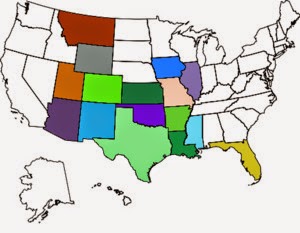
Overnight stays in these states:

Overnight stays in these states:
It is the sandstorm that shape the stone statues of the Desert. It is the struggles of Life that form a person's character ~ Native American Proverb