Remember that when you leave this Earth, you can take with you nothing that you have received, only what you have given, a full heart enriched by honest service, love, sacrifice and courage. -St. Francis of Assisi
Showing posts with label 2014. Show all posts

Monday, April 24, 2017

A *FREE Vacation

*Free - nothing is free :)
You will need to trade some hours of work for this *Free vacation

What does work-kamping mean to you?

Why do I "work-kamp"? 


This is a breakdown of my Cody, WY/Yellowstone "vacation in 2014"
May 5 to August 5, 2014
I left San Antonio,TX on May 5th and arrived in Cody on May 14th
archived blog posts can be found on the right side of the blog


Total Gross Wages...$3488.00   Travel Expenses*...$1496.00
Net  $1992.00

*Travel expenses are RV fuel and all RV campsite fees from
the time I started out in Texas in May until the time I left Cody in August
this includes the "job site rent" and trips on my days off 


I worked approx. 55 days/11 weeks
An 11 week working "vacation"
Note: this is the lowest paying workamping job I have had
I wanted to visit Yellowstone, so I agreed to it
My job: phone reservations
Bonus: meeting other work-kampers 


Where did I go and what did I see during these three months...

underlined titles will link to my blog posts

A benefit of working in Cody is that most of the attractions were free or discounted

Seasonal employees start with a tour from the Visitor's Center and then receive
 discounts/free passes to the attractions, including river rafting

I enjoyed all of these free attractions:
Buffalo Bill Center of the West
Trolley Tour of Cody
Rafting the Shoshone River
Old Trail Town
Heart Mountain Museum
Concerts in the Park
Music Revue


The Rodeo was a $10 annual pass, less than a single day admission


Along the way, or on my days off, I visited these towns and places

Texas
Wyoming
Chief Joseph Scenic Byway
Yellowstone National Park
Casper, Cody, Wapiti, Lovell
Wind River Scenic Byway
Shell Falls in Shell Canyon - Bighorn Mountains

Buffalo Bill Dam
Wapiti Ranger Station
Shoshone National Forest Campgrounds
Pahaska Tepee - Buffalo Bill's Camp
Shoshone River Trail

Montana

Red Lodge, Nye
Beartooth Highway - National Scenic Byway
Devil's Canyon Overlook
 Chief Plenty Coups State Park - National Historic Site
Cooney State Park, MT


As you can see from my list above and from the photos in my blog posts during the summer of 2014, this is a beautiful area of the country to visit. My RV is easy to setup/move and I would usually pack up and go camping on my days off of work.

If you plan to visit this area, you will need a week or more to see everything in Cody, you could easily spend 2 days at the Buffalo Bill Center of the West.


Depending on where you stay in or near Yellowstone, you will want at least a week, if not more time, to explore Yellowstone.  The park is huge and it takes a long time to get from section to section. This is one of the reasons that I opted to take a bus tour while in Yellowstone.


It took some time to set up this list, looking back and reading my blog posts from 2014 to make the links.


I miss the big beautiful blue skies and open prairies of Montana. I plan to return to this area.


If you don't need to get paid, and don't mind kicking in $$ for some of the expenses, you can "google" - Volunteer Vacations - and find some great places to visit.


Monday, November 17, 2014

Sunrise, beach and Balanced Rocks

Friday October 17

Up early to go outside for the sunrise, not as colorful as I hoped it would be.


A morning walk - I drove down to a parking area near the beach on the Colorado River and walked as far as I could in both directions until I ran out of beach and encountered the high canyon walls. 


Driving in yesterday, I passed by an area of balanced rocks and this morning I stopped to take pics on my way out. 


Balanced Rock 
Glen Canyon Recreation Area 

"Thousands of years ago a huge boulder of conglomerate broke from the cliff above and rolled to a stop here. Since then at least 6 feet of this slope has eroded away. Ultimately, the softer rock now protected by the umbrella of harder conglomerate will erode and the boulder will topple again to the ground." 


I walked all around this field of very tall boulders, luckily there was no movement of rocks. Don't think I would want to be near here during an earthquake. 


Well, its only around 8:30am at this point and I still have some driving to do heading toward the south rim of the Grand Canyon with no reservations for the night (Oct 17th with close to freezing temps possible overnight at the higher elevations).   

Several more posts are needed to try and catch up on this trip and my current location. 

Wednesday, November 12, 2014

Lees Ferry


There was a typo in the last post for the years the bridges were built, this has been fixed. 


Thursday, October 16

"Lees Ferry is the only place in Glen Canyon where visitors can drive to the Colorado River within over 700 miles of canyon country. A natural corridor between Utah and Arizona, it is the very start of the Grand Canyon." (Nps.gov)
 
Lees Ferry Campground does not take reservations but I could see empty sites as I drove past. When I arrived I went to the day use area first, it was too early to set up camp. 

Today I went from an elevation of over 8000' at the North Rim to 3210' at Lees Ferry (in only 85 miles) and the temperature has increased, its very hot here during the day. 

Changed out of jeans and long sleeve shirt into shorts, tshirt and hiking sandals so I could walk along the river trail and find a bit of shade to sit and enjoy the river scenery.


The campsites are $12, no hookups, on a cliff overlooking the Colorado River.  There were several empty sites and I was lucky to get a large site with a view of the river. 


Temps cooled down in time to sit outside and watch the sunset 


I tried out my "Solo Stove" to heat water for tea, it uses twigs for fuel. 


If it was cooler during the day I would have stayed more than one night. I really wish I had stayed longer - it was so calm and peaceful even with more than half of the campsites occupied.

--------------------
Still experimenting, using the iphone to write blog posts. 

I had a spam comment on the last blog post but the Blogger app does not let me get into the dashboard to mark comments as spam or delete them. 

Can't insert links or do any changes to the blog design with this app.

Vermillion Cliffs Highway

This post was created on my iphone, i hope the layout is ok as I have not looked at it on a computer. I wonder if the pictures are tiny. 


October 16, 2014

On Thursday morning I left the North Rim heading north on Hwy. 67, the only road out. At Jacob Lake I turned right, heading toward the South Rim but will camp along the way to break up the 5 hour drive. I always take my time and stop to check things out and I know it will take more than 5 hours. 


Hwy 89A skirts the southern border of Vermillion Cliffs National Monument.  A curvy, hilly drive through beautiful scenery. I stopped at several overlooks and pullouts to read signs and stretch my legs. 


At the House Rock Valley Overlook there was a short trail so I walked as far as I could to the edge of a cliff. 


Lunch was at Cliff Dwellers - sat at a table outside and enjoyed the view. Very good food and generous servings. 


The next stop was Navajo Bridge. The Interpretive Center was closed (they are remodeling after a fire, check online for a re-opening date) so I crossed the bridge and parked in a small parking lot on the other side. There was access here to walk across the original bridge. There are 2 bridges side by side. 


The bridges span Marble Canyon over the Colorado River. One built in 1924 (now a pedestrian bridge) and the newer highway bridge built in 1995. 

           Rafters under the bridge

I crossed back over the bridge and drove a short distance then turned toward Lees Ferry. 

to be continued...


Hiking @ the North Rim

"There is not one path. There is not even the right path.There is only your path and you know it's yours by how it feels to you."

August 15 - October 15, 2014

Well, I did what I came here to do. Hike the Grand Canyon - no, I did not do the Rim to Rim. I know my limitations, but was successful just the same.


I hiked on these trails at the North Rim
North Kaibab, Widforss, Bright Angel, Uncle Jim, Ken Patrick,
Bridle Path, Nature Trail and the Transept Trail 


Widforss Trail

Widforss Trail follows the canyon rim as it skirts the Transept, a large tributary of the Bright Angel Canyon.  The trail winds through a mixed spruce-fir forest to a picnic area near Widforss Point overlooking Haunted Canyon. 


Transept Trail


I walked down into the canyon, to the Coconino overlook.  Someday, maybe, who knows, I may come back to hike further down into the canyon.


The mule riders stop here for a break and the mules love to chew on this sign.


hiking back up to the rim

I left the North Rim on Thursday, October 16th.  It has been great, I was fortunate to have a beautiful, wooded site for 2 months at a very reasonable fee and earned some money to pay travel expenses and met some great friends.

Phyllis worked in the gift shop with me and we had one day off together each week, so she was my hiking buddy.

I also met up with a blogging friend, Ranger Gaelyn, and we went out to the Walhalla Plateau and to the Saddle Mountain Overlook. There are many, many places to explore on the North Rim, away from the Lodge area, if you have the right vehicle. I hope to come back someday with the right vehicle, a small, strong 4x4 mini camper that will take me out to all of these beautiful places.


Bye for now, North Rim, it holds great memories for me.................


Thursday, October 9, 2014

Trust Your Journey

About 10 years ago I read a book "Trust Your Vibes" and I try to follow my instincts in everything I do. Follow your intuition, believe in yourself, trust your choices.

Recently, I started following a page on Facebook - "Trust Your Journey".
Here are some of the inspirational sayings they have posted.


Nobody can go back and start a new beginning,
but anyone can start today and make a new ending.
-Maria Robinson


Faith is the daring of the soul
to go farther than it can see
-unknown


Trust Yourself
You know more than you think you do
-Benjamin Spock


A bend in the road
is not the end of the road
Unless you fail to make the turn
-unknown


I am not afraid of storms,
for I am learning to sail my ship.
-Louisa May Alcott


Your future is created by what you do today,
not tomorrow
-Robert Kiyasaki


Growth is painful,
change is painful.
But nothing is as painful
as staying stuck somewhere you don't belong
-Mandy Hale


Appreciate Yourself
and Honor your Soul
-Yogi Bhajan


Wherever life takes you,
Trust Your Journey
-Beth Brownlee


They also have a website with great products.  But, what I enjoy most are the inspirational saying that are posted to Facebook.

(I am not affiliated with the website or the products)

Monday, September 22, 2014

Bryce Canyon National Park

September 17-18, 2014   -   A mini-vacation from workamping.

"Hoo-doo" -  rock formations at Bryce Canyon

It was time to take the RV for a drive, I have been parked in one spot for a month. I saw a reminder post on Facebook about making sure to get all the engine parts moving on the RV at least once a month.

I decided on Bryce because the weather was expected to be cooler than other places around here.

It is a long drive to anywhere from the North Rim, The drive was about 3 1/2 hours one way.  I decided to stay overnight at Ruby's Inn RV Park right outside of the park. Bryce Canyon NP has a shuttle bus that stops at the RV park and at all of the viewpoints in the park.

I left the North Rim, at first light, at 6:00 am (7:00 am in Utah) and with stopping for gas and groceries, it was around noon by the time I had my house setup at the RV park.  Not the best time of day to start a hike into the canyon, but there was a possibility of rain later in the day and the next day, so I decided to go ahead and hike anyway.

A beautiful day except for about 10 minutes of rain in the late afternoon

After checking all of the information online and talking with my co-workers, I decided to hike the Navajo Trail going down into the canyon. the park service suggests walking the trail clockwise and then you will walk up into "Wall Street" at the end of the hike. Wall Street is like a slot canyon and then you go up more switchbacks back to the rim.

Wall Street

When I finished this hike, I took the shuttle bus to the Visitors Center to check things out and then sat outside to eat a lunch that I packed.  I did not go into the Lodge or the General Store because of the limited time I had on this short trip.


After lunch, I hiked some of the rim trail which is about 5 1/2 miles one way.  There was a little bit of rain late in the afternoon, so I took the shuttle bus between some of the viewpoints.


rain/rainbow at "Bryce Point"


Here is a picture of my late husband from May 2009 at Inspiration Point, he was standing very close to the edge and asked me to take his picture.  He wanted me to stand on the edge for a picture, but I would not do it. He said, "If you are not living on the edge, you are taking up too much space".
May 2009 "Inspiration Point" 

Now, I get close to the edge all the time while hiking, I don't seem to have the fears that I had in the past.  I tried to take a "selfie" at Inspiration Point but the pics did not turn out good.  I need to get an extension for my iPhone so I can take "selfies" while hiking.


Inspiration Point 9-17-2014


Friday, September 5, 2014

Touring with Ranger Gaelyn

Thursday, September 4, 2014


For several years, I have been corresponding with Gaelyn through our blogs. We both grew up in the Chicago area and both enjoyed spending time at Starved Rock State Park, so we have some things in common.

This is Gaelyn's 8th season as a ranger on the North Rim, she has been a seasonal park ranger for more than 20 years.

I arrived on the Kaibab Plateau on Thursday, August 15th and by coincidence met with Gaelyn in the parking lot at Jacob's Lake.  We both have Thursday off work and planned to get together today after the morning rains stopped.


We had a great afternoon exploring the Walhalla Plateau area of the North Rim.

Point Imperial,  Roosevelt Point, Cape Royal and Angel's Window

Lupine
We stopped along the side of the road to take pictures.


We spent a lot of time at the various overlooks, waiting for the light to change
and to watch the approaching storm, it was time to leave when we heard
the thunder and were losing daylight.


 I would love to explore inside this canyon.
 I'm hoping to go about a mile into the canyon before I leave here,
 and I will return another year to travel deeper into the canyon.


I am still learning the names of the rock formations, so I have not labeled these pictures.


If you want to see some great photos check out Gaelyn's blog - 

or check out her Facebook page https://www.facebook.com/Geogpsy


It is now after 9pm and I am listening to the wind and the rain as I write this. We had just a few hours without rain today to explore this area of the park and were not able to explore all of the trails and the ancient pueblo sites, but we did see the sky changing color as the sun started to set.


Drake Tax Software

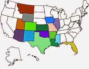
Overnight stays in these states:

Overnight stays in these states:
It is the sandstorm that shape the stone statues of the Desert. It is the struggles of Life that form a person's character ~ Native American Proverb